From Ermeshale to Emmy

  • About
  • Contact
  • Events
  • Frickley Colliery Fatalities
  • News
  • Places
  • People
  • Search this site

Top of Common Lane

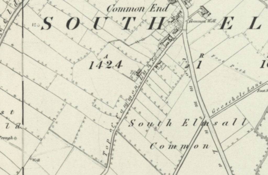
The 1854 Ordnance Survey map shows what is today Rowley Lane, was then known as Top Of Common Lane. The lane was then quite sparse, with just a handful of buildings and a pump. To the north east Top of Common Lane met with Common Lane (today Doncaster Road) and this area was known as South Elmsall Common.

Share this:

  • Share on X (Opens in new window) X
  • Share on Facebook (Opens in new window) Facebook
  • Share on LinkedIn (Opens in new window) LinkedIn
  • Share on WhatsApp (Opens in new window) WhatsApp
  • Email a link to a friend (Opens in new window) Email
  • Print (Opens in new window) Print

Recent posts

  • The Miner’s Institute, A Welcome Commitment to Restoration and Planning Consent Granted

    The Miner’s Institute, A Welcome Commitment to Restoration and Planning Consent Granted

  • Why is Our Heritage Worth so Little? The Proposed Solar Farm Problem

    Why is Our Heritage Worth so Little? The Proposed Solar Farm Problem

  • Is All Saint’s Church Falling Down?

    Is All Saint’s Church Falling Down?

  • Should The Grove, South Kirkby, Be Listed?

    Should The Grove, South Kirkby, Be Listed?

  • Are Our War Graves Safe?

    Are Our War Graves Safe?

  • HS2 Will Destroy South Kirkby Iron Age Camp

    HS2 Will Destroy South Kirkby Iron Age Camp

The Story of South Elmsall

  • About
  • Contact
  • Events
  • Frickley Colliery Fatalities
  • News
  • Places
  • People
  • Search this site

Website Powered by WordPress.com.


Loading Comments...
 

    • Subscribe Subscribed
      • The Story of South Elmsall
      • Already have a WordPress.com account? Log in now.
      • The Story of South Elmsall
      • Subscribe Subscribed
      • Sign up
      • Log in
      • Copy shortlink
      • Report this content
      • View post in Reader
      • Manage subscriptions
      • Collapse this bar