Prior to the first Ordnance Survey maps of the area being completed, the earlier 1770’s survey of the area by Thomas Jeffreys gives us a hint about something we see in postcards and photos of High Street, in the late 1800’s and early 1900’s, in that a stream or small rivulet can be seen running down the hill, parallel to the road track. The Jeffreys survey tells us that a water wheel was in operation in the late 1700’s on Mill Lane, which means that water would naturally have run down the hill from there.
Intriguingly, despite being a hub of activity and a major route through South Elmsall, the 1854 Ordnance Survey map did not see what we know today as High Street, specifically named, but due to it’s importance it is included here. At it’s southern end the road joined what is today Barnsley Road, at a junction known as Cross Hill. Here was one of the key hubs of South Elmsall, where the original Chequer Inn, South Elmsall School (Wesleyan), and smithy were located. As the road led north west up the hill it crossed over South Elmsall Bridge and past Elmsall Station and South Elmsall Steam Mill.
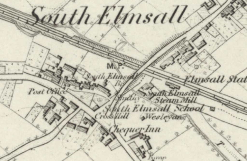
At it’s mid point, in 1854, what is now High Street was intersected by a junction known as Old Hill (which is today partly Upper Ash Grove), a built up area where a pump was located. Back Lane led from here north westerly. At it’s northern end what is now High Street was intersected by Mill Lane, and again this area was built up and contained a well, a pump, a towns house (poor house) and the South Elmsall pinfold. From here the lane transitioned to Field Lane.

An example of how old this road may be is a building located on what is today High Street is a subdivided sandstone building containing Hill House and Rock House Farmhouse. This building hides within it a timber framed range, whose earliest phase of building was sometime in the 1500’s, and it was enlarged in the 1600’s and again in the 1700’s. The timber framed range (Rock House Farmhouse) still today contains parts of two timber cross frames and the wall plate between these on the west side is still visible in the adjoining Hill House, along with jowelled wall posts, braces to the tie beams, and some wattle staves. On the first floor of Rock House Farmhouse there can be found an original chamber fireplace with 4-centred head. Hill House also has some large beams, and the exposed side of remains of 2 wall posts and a wall plate belonging to the original main range. This building is now grade II listed.
In the years directly leading up to the first Ordnance Survey map a number of lands in the vicinity of High Street were sold. In January 1827 the freehold lands of the late Mary Stocks were auctioned. These lands were extensive and included lot 21, a close of land known as North Croft and lot 22, a close of land known as Windmill Field Allotment (also known as Top of Town Close), in the occupation of Mr G. Smith.
In May 1844 the sale of the estate of the late Samuel Rowley, a farmer of South Elmsall, took place at Elmsall Inn (the home of William Wood). Samuel Rowley’s farm occupied a large part of what is today High Street, Upper Northcroft, Lower Northcroft and wider area and included a farm house, barns, cow houses, gardens and various plots of arable land, pasture and meadow. These were called The Croft, Gib Ing, Upper Norcroft, Lower Norcroft, Townend Close, First Shut Close (also known as New Close), Wall Close, Old Quarry Close, Turnpike Close, Far Manifold Hill, Near Manifold Hill (also known as Witch Flatt), Little Manifold Hill, Trough Close, Little Trough Close, Little Quarry Close (also known as Windmill Field), The Langleys, Green Field, New Close, The Hatchet (also known as West Field Close), The Hadcrofts, the Common Closes, Lockey Ing, Fleak Close and Old Hill. It was said that the buildings were commodious and in “good repair” and the land was largely tithe free and “in an excellent state of cultivation.”
In November 1853 large areas of lands across the area were auctioned at the Chequers Inn (home of William Wilson) that were the freehold estate of the late George Booth. These included many closes of arable, pasture and meadow land, split up into lots, including lot 2, two cottages in North Croft Road in the possession of Thomas Rickard and John Tyas respectively, undertenants to James Brook. North Croft Road was not included on the 1854 Ordnance Survey map of South Elmsall but presumably was close to what is now High Street and Upper Northcroft and Lower Northcroft. Also sold were lot 10, grassland known as North Croft and lot 11, two grass closes known as Top North Croft and Low North Croft.